Asia-Pacific Analysis
The South China Sea Dispute Explained
China claims nearly all of the South China Sea. Five other claimants contest parts of it, and a 2016 tribunal rejected Beijing's historic-rights claim. Here is who claims what, what the law says and why the shoals off the Philippines keep flaring.

In short
- Six claimants contest the South China Sea: China, Taiwan, Vietnam, the Philippines, Malaysia and Brunei. China's dashed line also overlaps Indonesia's exclusive economic zone off the Natuna Islands.
- On 12 July 2016, a tribunal under the UN Convention on the Law of the Sea found no legal basis for China's claim to historic rights inside the nine-dash line; China calls the award null and void.
- China has built bases on Fiery Cross, Subi and Mischief Reef. As of May 2026, AMTI put China's artificial land at about 5,460 acres and Vietnam's at about 2,771 acres.
- CSIS's ChinaPower project estimated that about $3.37 trillion of trade passed through the sea in 2016, about 21% of global trade.
- In September 2026, the Philippine armed forces counted 101 Chinese vessels in the waters Manila calls the West Philippine Sea, up from 56 in August, GMA News reported.
In this analysis 8 sections
- 01Who claims what in the South China Sea dispute?
- 02What is the nine-dash line, and why does China claim historic rights?
- 03What did the South China Sea arbitration decide in 2016?
- 04How did island building change the South China Sea?
- 05Why are Second Thomas Shoal and Scarborough Shoal flashpoints?
- 06Why does the South China Sea matter to the world?
- 07What to watch next
- 08Frequently asked questions
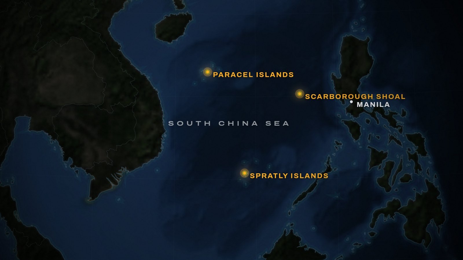
In September 2026, the Philippine armed forces counted 101 Chinese vessels in the waters Manila calls the West Philippine Sea, GMA News reported. That was up from 56 in August. Around Scarborough Shoal alone, they counted 25 Chinese coast guard ships and 14 navy ships.
Those numbers show how the South China Sea dispute works today. Governments press their claims with patrols, water cannon and maps, not open war. This guide explains who claims what, what international law says, where the clashes happen and why the rest of the world cares.
Who claims what in the South China Sea dispute?
Six claimants contest the sea or parts of it. China claims nearly all of it, inside a dashed line on its maps. The others claim islands, reefs and waters closer to their own coasts.
| Claimant | What it claims | What it holds or does |
|---|---|---|
| China | Nearly all of the sea | The Paracels; bases on Fiery Cross, Subi and Mischief Reef; Scarborough Shoal since 2012 |
| Taiwan | The islands on the same 1947 map | Itu Aba (Taiping Island) |
| Vietnam | All of the Paracel and Spratly Islands | About 2,771 acres of reclaimed land (AMTI, May 2026) |
| The Philippines | Scarborough Shoal, part of the Spratlys, its EEZ | Thitu Island; the BRP Sierra Madre |
| Malaysia | Waters off Sarawak, including Luconia Shoals | Offshore oil and gas projects |
| Brunei | Part of the sea | |
| Indonesia (not a claimant) | Its EEZ off the Natuna Islands | Rejects China’s line |
Taiwan and Vietnam
Taiwan’s claim comes from the same 1947 map as Beijing’s. It holds Itu Aba, also called Taiping Island, which at 46 hectares is the largest natural island in the Spratlys. However, the Asia Maritime Transparency Initiative (AMTI) at CSIS notes that Taiwan has never claimed historic rights to all the waters inside the line.
Vietnam claims all of the Paracel and Spratly Islands, citing historical and legal evidence. It wants disputes in the South China Sea settled peacefully under international law. China took the Paracels after a naval clash with South Vietnam in 1974 and still holds them. Then, in 1988, a clash at Johnson South Reef left 64 Vietnamese dead, according to Radio Free Asia.
The Philippines, Malaysia and Brunei
The Philippines claims Scarborough Shoal and part of the Spratlys, including Thitu Island, which it controls. It rests its case on the UN Convention on the Law of the Sea (UNCLOS), the 1982 treaty behind the 200-nautical-mile exclusive economic zone (EEZ).
Malaysia claims waters off Sarawak, on Borneo, where it runs major oil and gas projects. AMTI tracked nine Chinese coast guard ships in Malaysia’s EEZ between January and September 2024, mostly around Luconia Shoals. Even so, Prime Minister Anwar Ibrahim has said Malaysia will keep extracting resources there. Brunei also has an overlapping claim.
Indonesia: not a claimant, but affected
Indonesia says it is not a claimant. China does not contest its sovereignty over the Natuna Islands, but China’s line overlaps the EEZ that Indonesia draws from them. Indonesia renamed the area the North Natuna Sea in 2017. In 2019, its foreign ministry said it would never recognise the line.
What is the nine-dash line, and why does China claim historic rights?
The line began with eleven dashes. The Republic of China’s interior ministry drew it around the Paracel and Spratly Islands on a map of 1 December 1947, according to a study for Japan’s Cabinet Secretariat. After the Communists won China’s civil war in 1949, the People’s Republic kept the claim and later redrew it with nine dashes.
China’s case rests on history. Its foreign ministry says China’s sovereignty and rights in the sea formed over a long history, and that successive Chinese governments have upheld them. Its embassy in Manila describes those rights as grounded in both history and law. In other words, Beijing argues that its rights come from history, not only from the modern law of the sea.
The 2023 “standard map”
On 28 August 2023, China’s Ministry of Natural Resources published a new “standard map”. It showed ten dashes, with an extra one east of Taiwan. The Japanese study reads that tenth dash as a way to press Beijing’s claim to Taiwan.
The Philippines rejected the map, saying the 2016 arbitral award had already invalidated the old line’s claims. Malaysia rejected China’s “claims to sovereignty, sovereign rights and jurisdiction”. Beijing described the release as routine.
What did the South China Sea arbitration decide in 2016?
In 2013, the Philippines brought a case against China under UNCLOS. China refused to take part and rejected the tribunal’s jurisdiction. On 12 July 2016, the tribunal issued its award. Its main findings were these:
- China had no legal basis to claim historic rights to resources inside the nine-dash line. Any such rights ended where they clashed with the EEZs that UNCLOS creates.
- No Spratly feature, nor Scarborough Shoal, can generate a 200-nautical-mile EEZ.
- Mischief Reef and several other Spratly features are low-tide elevations, which no state can appropriate.
- China had violated the Philippines’ sovereign rights, and its reclamation had caused severe harm to the marine environment.
The tribunal did not decide who owns any island or reef, and it drew no boundaries. So the South China Sea dispute over sovereignty remains open.
How China and its neighbours responded
In a statement on 12 July 2016, China’s foreign ministry declared the award “null and void” and said China neither accepts nor recognises it. It repeated that position in 2022.
“China’s territorial sovereignty and maritime rights and interests in the South China Sea shall under no circumstances be affected by those awards.”
China’s Ministry of Foreign Affairs, statement on the award, 12 July 2016
For Manila, the award settled the legal question. On 27 July 2026, President Ferdinand Marcos Jr vowed in his state of the nation address to uphold it. Vietnam was not a party, but it rejects the nine-dash line as inconsistent with UNCLOS.
How did island building change the South China Sea?
China turned three reefs in the Spratlys into bases: Fiery Cross, Subi and Mischief Reef. In September 2015, satellite images taken for CSIS showed a strip about 3,000 metres long at Mischief Reef. AMTI’s Greg Poling told Reuters it was probably being prepared as a runway, China’s third in the Spratlys.
In March 2022, Admiral John Aquilino, the top US commander in the Indo-Pacific, said missile arsenals, hangars, radar systems and other facilities on the three reefs appeared complete. Radio Free Asia reported his view that Subi Reef was “fully militarized”.
China is not the only builder, though. In May 2026, AMTI put Vietnam’s reclaimed land at about 2,771 acres, after it added about 534 acres in a single year. China’s total stood at about 5,460 acres, driven up by new work at Antelope Reef.
Why are Second Thomas Shoal and Scarborough Shoal flashpoints?
Most clashes now pit China against the Philippines, at two shoals.
Second Thomas Shoal
In 1999, the Philippines deliberately ran an old warship, the BRP Sierra Madre, aground on Second Thomas Shoal. It still serves as an outpost that backs Manila’s claim, so the Philippines resupplies it and rotates its crew. Beijing wants the ship removed.
On 17 June 2024, Chinese coast guard personnel seized guns from a Philippine resupply mission, and a Filipino sailor lost a thumb. In July 2024, the two sides reached a provisional arrangement for resupply, but each described it differently. China said Manila must inform it in advance and accept Chinese monitoring, which Manila disputed.
Even so, the deal held for a time. AMTI counted 13 missions under it through 4 March 2026, and Philippine officials said they passed without dangerous encounters. That calm broke in July 2026. The Philippine military said Chinese coast guard personnel struck a Filipino sailor with a baton near the ship, and the two militaries traded accusations.
Scarborough Shoal
China calls Scarborough Shoal Huangyan Island; the Philippines calls it Bajo de Masinloc. China has controlled it since a stand-off in 2012. Both countries claim sovereignty, and the 2016 award did not settle it. However, the tribunal found China’s blocking of access unlawful and called the shoal a traditional fishing ground for several countries.
Since then, Beijing has tightened its hold on paper. In November 2024, it published territorial sea baselines around the shoal. In September 2025, its State Council approved a nature reserve there, calling it an “important guarantee” for the atoll’s ecosystem. Manila called the reserve a “clear pretext for occupation”.
The waters carry real risk. On 11 August 2025, a Chinese coast guard ship collided with a Chinese navy ship near the shoal. According to a US Senate resolution, the coast guard ship was “harassing” a Philippine vessel at the time.
What has happened in 2026?
The pressure has continued in 2026, from navy ships as well as coast guards. In late May, a Chinese floating platform appeared at Scarborough Shoal. Beijing said it supported scientific research, and on 17 June Manila said it had been removed. In mid-June, a Philippine frigate met Chinese navy ships near the shoal, according to the Philippine military.
Then, on 23 July, Manila said a Chinese coast guard ship fired a water cannon at a Philippine government vessel near Scarborough. China’s coast guard said it had acted lawfully and professionally.
Why does the South China Sea matter to the world?
The sea is a trade route, a fishing ground and a possible source of energy. That is why the South China Sea dispute draws in countries far beyond its shores.
| Measure | Figure | Source and year |
|---|---|---|
| Trade passing through the sea | About $3.37 trillion, about 21% of global trade | CSIS ChinaPower, 2016 |
| Share of China’s maritime trade | More than 64% | CSIS ChinaPower, 2016 |
| Oil, proved and probable reserves | About 11 billion barrels | US EIA, 2013 |
| Gas, proved and probable reserves | About 190 trillion cubic feet | US EIA, 2013 |
| Share of the world’s fish catch | About 12% (contested) | AMTI estimate |
Trade: what the $3.4 trillion figure means
The most-quoted trade figure, about $3.4 trillion, comes from CSIS’s ChinaPower project. It is an estimate for one year, 2016, not a current yearly count. It replaced an older figure of $5.3 trillion, which traced back to remarks in 2010 by a US admiral, Robert Willard.
Ships from the Indian Ocean enter the sea through the Strait of Malacca, the world’s largest oil chokepoint by volume, as our guide to global trade chokepoints explains. When a major sea lane closes, the shock spreads fast, as the 2026 crisis in the Strait of Hormuz shows.
Fish, oil and gas
AMTI’s Greg Poling has estimated that about 12% of the world’s fish catch comes from the South China Sea. However, the Australian Strategic Policy Institute warns that the statistics behind such figures are not entirely reliable.
In 2013, the US Energy Information Administration estimated about 11 billion barrels of oil and 190 trillion cubic feet of gas in proved and probable reserves. Most of it lies in uncontested waters near the coasts, not around the disputed islands. By contrast, China’s CNOOC claimed about 125 billion barrels and 500 trillion cubic feet, which the EIA said independent studies had not confirmed.
Where does the United States stand?
The United States is not a claimant, but it acts in two ways. First, its navy sails close to features that others claim. On 27 October 2015, the destroyer USS Lassen sailed within 12 nautical miles of Subi Reef, asserting the right of ships to pass whatever the reef’s legal status. Two Chinese warships shadowed it and warned it to leave.
Second, Washington is allied with Manila. In October 2025, after a ramming and water-cannon incident near Thitu Island, the State Department restated its position, NBC News reported. Article IV of the 1951 Mutual Defense Treaty, it said, covers armed attacks on Philippine armed forces, public vessels or aircraft, including its coast guard, anywhere in the South China Sea. Washington has used that wording before. Beijing issued its own warning over the same clash.
What to watch next
Four things will shape the South China Sea dispute in the coming months.
First, the code of conduct. In July 2023, ASEAN and China agreed to try to conclude one within three years. The Philippines, this year’s ASEAN chair, has pushed for monthly talks, and on 24 July 2026 Foreign Secretary Theresa Lazaro reported “good progress”. Yet whether the code will be legally binding remains unresolved.
Second, Second Thomas Shoal: whether the 2024 resupply arrangement survives the July 2026 clash.
Third, Scarborough Shoal. The nature reserve, any new structures and the number of Chinese ships there will show how far Beijing wants to go.
Last, the navies. On 14 October 2026, USNI News reported that a Chinese carrier strike group was heading to the South China Sea after drills in the Philippine Sea. For more analysis on Asia-Pacific, see our regional page.
Frequently asked questions
Which countries are involved in the South China Sea dispute?
Six claimants are involved: China, Taiwan, Vietnam, the Philippines, Malaysia and Brunei. China claims nearly all of the sea inside its dashed line. Indonesia says it is not a claimant. However, China’s line overlaps the exclusive economic zone that Indonesia draws from its Natuna Islands, in waters Jakarta calls the North Natuna Sea.
What did the South China Sea arbitration award decide?
On 12 July 2016, a tribunal under UNCLOS ruled in the Philippines’ case against China. It found no legal basis for China’s claim to historic rights inside the nine-dash line. It also found that no Spratly feature generates a 200-nautical-mile zone. It did not decide sovereignty. China calls the award null and void.
What is the nine-dash line?
The nine-dash line is the dashed line on Chinese maps that encloses most of the South China Sea. It began as an eleven-dash line on a Republic of China map in 1947. China’s 2023 standard map shows ten dashes, adding one east of Taiwan. Several neighbours and the 2016 tribunal reject the claim behind it.
Why is the South China Sea so important?
It is a major trade route, fishing ground and possible energy source. CSIS’s ChinaPower project estimated that about $3.37 trillion of trade passed through it in 2016, about 21% of global trade. In 2013, the US Energy Information Administration estimated 11 billion barrels of oil and 190 trillion cubic feet of gas in proved and probable reserves.
Would the US defend the Philippines in the South China Sea?
US officials say the 1951 Mutual Defense Treaty applies there. In October 2025, the State Department said Article IV covers armed attacks on Philippine armed forces, public vessels or aircraft, including its coast guard, anywhere in the South China Sea. It said so after a ramming and water-cannon incident near Thitu Island.
What is happening at Second Thomas Shoal?
The Philippines keeps a crew on the BRP Sierra Madre, a warship it ran aground there in 1999. Resupply missions led to clashes with China’s coast guard, including one in June 2024. A provisional arrangement from July 2024 calmed things until July 2026, when Manila said Chinese personnel struck a Filipino sailor.
Sources
- Chinese vessels in West Philippine Sea reached over 100 in September 2026
- AFP: Chinese vessels spotted in West Philippine Sea increased to 56 in August 2026
- Philippine military says China injured sailor in South China Sea clash
- Commentary on Taiwan's position in the South China Sea
- Taiwan implicitly clarified U-shaped line
- Vietnam marks anniversary of naval clash with China over Spratly Island reefs
- Vietnam country profile, Maritime Awareness Project
- US backs Philippine ally after China warns over vessel clash
Show all 48 sources
- Final award published in the South China Sea arbitration
- A well-oiled machine: Chinese patrols at Luconia Shoals
- Indonesia country profile, Maritime Awareness Project
- China-Indonesia: a new tug of war
- Indonesia protests Beijing's alleged encroachments around Natuna Islands
- Research column on the dashed line in Chinese maps
- Senkaku Islands research series, chapter 4 column
- UN tribunal ruling 'null, void, nonbinding' — China
- China rejects South China Sea arbitral ruling, says it 'violates international law'
- DFA files protest against China's new 10-dash line
- Malaysia, India protest China's latest South China Sea map
- Report on China's 2023 standard map and the reactions to it
- The South China Sea ruling: Philippines v China
- Statement on the award of the arbitral tribunal in the South China Sea arbitration
- 'We do not yield': Marcos vows to uphold 2016 arbitral ruling in SONA
- A regional security hotspot in the South China Sea
- China building third airstrip on disputed South China Sea islets: expert
- Imagery shows China still building on Subi Reef in South China Sea
- Keeping score: Vietnam's Spratly Island overhaul continues
- Divergence and tacit understanding in the China-Philippines provisional arrangement at Second Thomas Shoal
- Second Thomas Shoal: deal or no deal?
- Philippines slams China's plan for nature reserve in disputed shoal
- China conducts naval, air patrols around disputed shoal in South China Sea
- S.Res. 409 (119th Congress), resolution on the 74th anniversary of the US-Philippines Mutual Defense Treaty
- AFP, US counterpart hold bilateral drills in West PH Sea amid Chinese activities in Scarborough
- China places platform inside Bajo de Masinloc
- Philippines says floating platform removed from Scarborough Shoal
- China fires water cannon on Philippine ship at Scarborough Shoal, Manila says
- Chinese Carrier Strike Group Heads to South China Sea After Philippine Sea Drills
- How much trade transits the South China Sea?
- How much trade transits the South China Sea? Not $5.3 trillion a year
- World Oil Transit Chokepoints
- China's assault on South China Sea fisheries: doing the maths
- Today in Energy note on South China Sea oil and gas
- U.S. report details rich resources in South China Sea (CNA)
- The U.S. asserts freedom of navigation in the South China Sea
- China and ASEAN agree to try to conclude nonaggression pact on sea feud in 3 years (AP)
- ASEAN aims to complete South China Sea COC by 2026
- Philippine News Agency report on ASEAN-China code of conduct talks
- Line in the sand: ASEAN must choose substance over speed in the South China Sea
Facts as of 16 October 2026. Spotted a mistake? Tell us, and we will correct it.